Nibbles4Ever
1 more day ^^
I like how detailed the cities are.
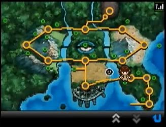
I'm pretty sure that's not the in-game map. That's the High Link map, isn't it? High Link doesn't cover the entire region, only a small, Pokeball-shaped sector of it. (Something tells me you enter High Link by teleporting to the center section, where you then enter the whirlwind structure and teleport to a "blip" in the larger circle.)
I mean, look at the girl icon near the bottom-right area. That's the Wi-Fi avatar of the player that you choose (or perhaps the Wi-Fi avatar of another player you're doing a mission with?), why else would it be there?
The actual in-game map (probably called the "Town Map") will include the entire region, not just the innermost area.
I also noticed that there are no routes to the central structure. Any I deas as to why (based on the in game map)?
Wrong.
This is the High Link Area Map:
http://i38.*******.com/28a2ueu.png
The other is the Town Map.
I'm pretty sure that's not the in-game map. That's the High Link map, isn't it? High Link doesn't cover the entire region, only a small, Pokeball-shaped sector of it. (Something tells me you enter High Link by teleporting to the center section, where you then enter the whirlwind structure and teleport to a "blip" in the larger circle.)
I mean, look at the girl icon near the bottom-right area. That's the Wi-Fi avatar of the player that you choose (or perhaps the Wi-Fi avatar of another player you're doing a mission with?), why else would it be there?
The actual in-game map (probably called the "Town Map") will include the entire region, not just the innermost area.
")
I'm pretty sure that's not the in-game map. That's the High Link map, isn't it? High Link doesn't cover the entire region, only a small, Pokeball-shaped sector of it. (Something tells me you enter High Link by teleporting to the center section, where you then enter the whirlwind structure and teleport to a "blip" in the larger circle.)
I mean, look at the girl icon near the bottom-right area. That's the Wi-Fi avatar of the player that you choose (or perhaps the Wi-Fi avatar of another player you're doing a mission with?), why else would it be there?
The actual in-game map (probably called the "Town Map") will include the entire region, not just the innermost area.
Then what is up with the girl icon? Why is she there?
As Sabonea_Masukippa said, the girl is an icon to show that another player is using the High Link function.
Just for clarity (I'm not trying to be mean or anything) High-link =/= C-Gear=/= PGL/Dream World.
They're three seperate functions that all happen to use some sort of wireless connection.
Nah, I'm not offended.
Looks like I made a mistake, instead of High link, I meant C-gear.
Isn't it still possible that the C-Gear map doesn't correspond completely with the Town Map? I thought C-Gear related to High Link's mission mode thing.
Isn't it still possible that the C-Gear map doesn't correspond completely with the Town Map? I thought C-Gear related to High Link's mission mode thing.
I noticed that, too. I wonder, if it is available, how surf would be utilized? Maybe surfable areas within the caves?
edit: Here's the in-game map so you know what I am talking about:
I also noticed that there are no routes to the central structure. Any I deas as to why (based on the in game map)?
Oh and to answer your question, B City/W Forest should be in the top left corner somewhere.
I don't know how I missed pointing this out considering how many times I've seen that image, but one would be inclined to believe surf will be necessary if you look at the dot in the sea to the east. I don't see any land over there...
I don't know how I missed pointing this out considering how many times I've seen that image, but one would be inclined to believe surf will be necessary if you look at the dot in the sea to the east. I don't see any land over there...
Well, it's possible they don't completely correspond. However, it still doesn't explain why the hell the player is no where near a route on the map.
Arjay said:I think he/she meant a "visible" route.
There's also that water route that stops in the middle of the sea to the left of Kanoko Town (starting town).
If you look at the drawn map, there is an island down there with a structure on it. That's probably where that route goes.
I know, that's what I was talking about in the first part.
There's gotta be something important in that building on the island. Any ideas?
Maybe it's the PokeShifter place?
Pal Park was close to Twinleaf Town... But that's just dumb speculation.. XP
Maybe the map only details where the player has been so far? Because there are most likely more routes